
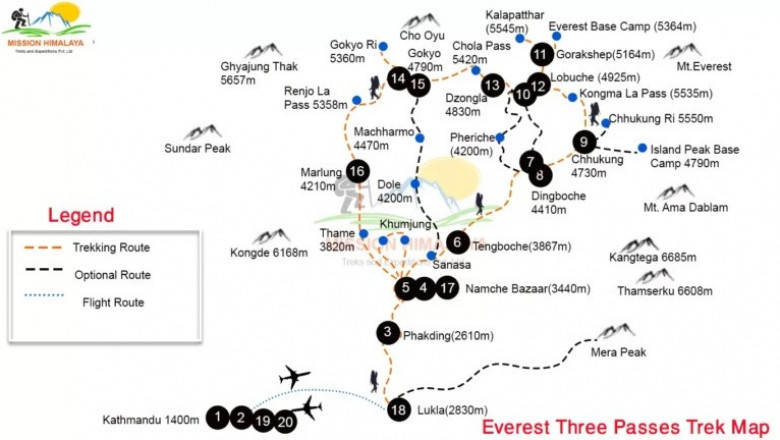
When we decided to take on the Three Passes Trek, the first thing we did was study the Three Passes Trek map. This trek is one of the most thrilling and rewarding journeys in the Everest region. It connects some of the best places in the Himalayas and takes you over three high mountain passes. For us, the map was not just a tool. It was a companion that guided us through each village, valley, and peak.
In this article, I will explain how the map helps during the trek and what you can expect from the route. I’ll keep it simple and clear, based on our real experience on the trail.
Why the Three Passes Trek Is Special
The Three Passes Trek is different from a straight route like Everest Base Camp. It is a circular trail that includes three major high passes. These are Kongma La (5,535m), Cho La (5,420m), and Renjo La (5,360m). Along the way, you also get the chance to visit Everest Base Camp, Gokyo Lakes, and several beautiful Sherpa villages.
We chose this trek because we wanted to go beyond the usual trails. We wanted to see more and challenge ourselves. With the map in hand, we always knew where we were and where we were going next.
Starting the Trek: Lukla to Namche
We flew into Lukla and followed the trail to Phakding and then to Namche Bazaar. Namche is the main town in the Khumbu region. It was the first big stop where we checked the map again and planned our next steps. Most people stay here for one or two nights to get used to the altitude.
From Namche, the map shows two directions. You can either go east toward Kongma La or west toward Renjo La. We decided to go clockwise, which many people suggest because it gives you more time to acclimatize before the toughest pass.
The Route Across the Passes
The first pass we crossed was Kongma La, which connects Chhukhung to Lobuche. It was the highest and the most quiet. There were very few trekkers, and the view was wild and untouched.
Next, we followed the map to Everest Base Camp and Kalapatthar. These are side trips but easy to manage if you plan well. After seeing Everest up close, we moved toward Dzongla and crossed Cho La Pass to reach Gokyo.
The Gokyo Valley was peaceful and stunning. We climbed Gokyo Ri for sunrise views and then headed over our final challenge, Renjo La Pass, which offered a wide and dramatic view of the Himalayas. We then descended to Lungden and walked back to Namche, closing the full loop.
How the Map Helps
The Three Passes Trek map is very helpful because the trail is long and covers many remote areas. Some sections are well marked, but others are not. The map showed us key points like villages, rest stops, altitudes, and time estimates between places.
Even though we had a guide, we kept checking the map to track our progress. It helped us plan our days and know how far we had to go. When the weather changed or we felt tired, the map gave us options for rest or shorter routes.
Final Thoughts
The Three Passes Trek is an adventure you will never forget. Having a clear and detailed map makes a big difference. It shows you the whole journey and helps you stay safe and confident in the mountains.
We completed the loop with pride and many great memories. If you are planning this trek, take time to study the map. It is your best guide to explore the beauty of the Everest region with freedom and clarity.


![Fitness Technology Market [2025-2033] is Growing Rapidly at Upcoming](https://timessquarereporter.com/upload/media/posts/2025-04/15/fitness-technology-market-2025-2033-is-growing-rapidly-at-upcoming_1744711056-s.jpg)
Comments
0 comment